Tuesday, October 25, 2011

Always Something There to Remind Me

Africa 2010-11
Trip Statistics


Departure:   November 03, 2010
Return:        March 16, 2011


Nights Stayed by Country:
  1. Morocco                  12
  2. Tunisia                    11
  3. Egypt                      10
  4. Israel                       12
  5. Jordan                       6
  6. Ethiopia                   12
  7. Kenya                        6
  8. Uganda                    11
  9. Tanzania                  13
  10. Zambia                      4
  11. Botswana                   6
  12. Namibia                    10
  13. South Africa              17
  14. Lesotho (day trip)       0  
                                       133* (19 weeks)

*includes 3 nights in transit

Other Data:

>Unique hotels / campsites:           81* 
>Average stay / location                1.6 days
>Inter-city/country flights:            14  
>Inter-city overland transport:       47
  (ex. 2 car rentals of 17 days)
>Organized excursions/activities:   43 
>MacDonalds' Visits:                       5 (3 were Les for Sundaes)
  (Egypt/Israel/South Africa)
>Highest Point:                              3,925 metres (12,880 feet)
(Simien Mountains, Ethiopia)
>Lowest Point:                              -423 metres (-1,388 feet) 
  (Dead Sea, Israel/Jordan)
>Blog Entries                                  28 (including this one)          


Total    Distance Travelled         54,423 kilometres (33,817 miles)
     Within Africa                  30,425 kilometres (18,905 miles)
     Average / day                       229 kilometres (142 miles)

Tuesday, May 31, 2011

Darkness on the Edge of Town (South Africa)

As much as South Africa’s first world charms are quite pleasant and appealing, especially when compared to much of East and North Africa, there are still some disturbing distinctions from the first world.  Adjacent to every city and town is a shanty, proportionally smaller but still of a considerably size – an overhang from Apartheid.  We visited one of the most significant on the outskirts of Capetown (called Langa) as part of an organized tour.  Residents invited us into their very humble homes and highlighted the various recent building improvements (continuous electricity, running water and indoor plumbing), and even sections of newly constructed social housing to replace what must be embarrassing to the national authorities (things did accelerate somewhat as a result of the World Cup).

Despite the squalor, the neighbourhoods have a vibrant social scene with many churches, clubs and makeshift play areas.  Stalls and garage sale like tables surrounded our route with offerings of local crafts, much of it made from refuse metal, cardboard and other scrap material.  At every turn, the faces of the smiling children abound, belying their circumstances.  This scene is repeated throughout the country – albeit on a less commercial scale than in the major cities.
Despite the spectacular road and tourism infrastructure, other indications that the country is not quite “there” yet include a tendency for private homes and even whole neighbourhoods, to be protected by fences six to eight feet high and topped with barbed or electrified fencing.  Most of the B&B’s and modest hotels we stayed at actually advertized their secure parking facilities.  At most shopping centres, the services of a parking attendant (sometimes official, sometimes not) was always available for a few Rand to ensure the safety of your vehicle.

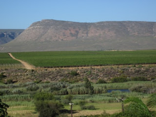
The economic disparity is best illustrated when visiting the “other” suburbs of Capetown, in the affluent wine region.  We spent the day sampling the wines in Stellenbosch, a spectacular setting where perfectly linear rows of lush green vines are juxtaposed against the surrounding jagged and dry taupe mountain peaks.   The town itself is chock a block with upscale souvenir shops and casual restaurants, with fine dining available at a few estates.  We chose to sample the favourites of Ernie Els at his namesake winery - not sure how much time he spends at the facility now that he lives in the U.S., but he did meet his wife there, and they did have a bit of a golf shrine and some apparel for sale.  Not surprisingly, the fields were mostly populated with workers likely living some distance away in their own shanty suburb.
The Garden route is a highly touted scenic and historic network of roads running along dazzling coastline and through the astonishing interior mountain passes (not least for the incredible feats of steep switchback engineering). 


The route is littered with small towns offering a variety of traditional and offbeat adventure attractions.  In Hermanus we thought we’d try one of the latter activities - shark cage diving.  A group of about 20 of us slid out of harbour aboard a boat that seemed eerily similar to the one I remember concerned Richard Dreyfus in the film Jaws.  In groups of five, we donned our wetsuits and masks for the plunge.  The deck hands began to toss fish heads around the steel cage in order to attract our special guests (our only instructions were to keep our hands and feet within the cage – “mmm people fillet fingers”).   Their arrival (to within a couple of feet of the cage) almost made me forget about the frigid 15C waters permeating my very being – all the way to my vital organs.  This might have actually been the proverbial “once in a lifetime experience”.


After that close encounter we chose to veer towards the mountains to visit the Cango Caves - with a special optional route through tight crevices and cracks.  It was most recently in the news when 12 visitors were stuck for 10+ hours as a result of a rotund visitor who became wedged within.  There are now life-sized simulations at the entrance for folks to self-exclude.
Further en route we: checked out an Ostrich farm (where aside from feeding them and standing on their eggs, I got to ride one); 

(video of my Ostrich ride on flickr - see below)

hit some seaside links;
found a secluded beach;

hiked a few national park trails;

ventured into a couple of urban Casino complexes (replete with gun check rooms?); stumbled into a major national festival in the independent country of Lesotho (entirely encircled by S. Africa); and ended our African extravaganza in Johannesburg to decompress with some museums, golf, shopping and dining.
 
Before returning the car rental to the airport for our flight home, we also had to clean up from the mudfest we accidentally encountered on one of our many wrong turns and at least try to deflect attention from the missing hubcap (how did that happen?).

For more South Africa Photos - see flickr at:
http://www.flickr.com/photos/thegoobers_pics/sets/72157626855304036/
(includes Ostrich riding video).


Stay tuned for the African Journey Summary Statistics…


Tuesday, May 3, 2011

Life is a Highway (South Africa)

The north-west of South Africa is quite sparsely populated with rolling hills perfectly suited for their famous Rooibos Tea plantations. 
This is also the first time on our trip where we encountered vineyards – a welcome sight after six weeks of abstinence in the North African predominantly Muslim countries and relatively poor supply of quality wines throughout East and Southern Africa.
We had been told (mostly by South Africans) that Capetown is a beautiful city with a spectacular harbour – but that’s what everyone says about their own city.  Well, in this case, they were spot on.  An enveloping chain of cliffs with the famous Table Mountain backdrop surrounds a rugged coastline of rocky coves, small islands and crescent beaches. 
This natural setting is enhanced by recent upgrades as part of World Cup preparations, with a modern architectural stadium, pleasant avenues and pedestrian malls, and possibly the most attractive dockland in the world.  A series of basins and piers comprise the centrepiece V&A waterfront complex of shops, condos, marinas and converted historic buildings housing art and craft centres.

Just offshore – about a half hour by ferry – is Robben Island, the location where Nelson Mandela was incarcerated.  The half day spent there offered new insights into the origins and history of Apartheid.  Just as in Cambodia or Rwanda, South Africa has chosen to acknowledge and highlight the truths of this dark period in their recent past as a testament and lesson.  Past prisoners lead the penitentiary tours offer personal and heartfelt insights, outlining the how comprehensive the ignorance really was with countless classifications for different combinations of racial mixes making up the category of non-whites, as well as the unscientific “Nazi-like” determination techniques  (i.e. width of nose, whether a pencil can be held within coiled hair).
Nelson Mandela's Cell

The Master Key
The drive south to The Cape of Good Hope ranks with the best scenic routes anywhere (Pacific Coast Highway #1, Great Ocean Road, Cabot Trail, etc).  The breathtaking vistas begin with a series of upscale Capetown beach neighbourhoods sprinkled along the jagged tiered coastline.  Chapman’s Peak drive funnels through the serrated sentinel mountains periodically twisting around sharp turns carved around the rock ledges making it a bit perilous if your view lingers on the majestic views of the sea and surf.  
There are also numerous warnings regarding encounters with wild baboons especially if planning a roadside picnic (which we did).


The end of the line is Cape Point, with its obligatory light house and viewpoints (although not technically the southernmost point in Africa), and the turning point around the peninsula for the trip back north.
Lighthouse on Cliff

We made a quick stop at Boulders Beach in Simonstown to catch a glimpse of the African Penguin colony (renamed from Jackass Penguins - not sure why but not surprisingly I do have quite a few theories – a striking similarity to the actions of local political figures, copyright infringement with the TV show/movies of the same name, animal rights group representing burro/mule/donkey sensitivity concerns).
We had opted for a bit of first world travel for the South African leg of the trip with a rental car for the projected 14 days from Capetown to Johannesburg.  Our next stop would be the wine region of Stellenbosch.

Thursday, April 7, 2011

Have you ever seen the Rain? (Namibia)

The route south from Etosha exemplified the diverse and starkly beautiful geography of Namibia.  An afternoon exploring the rocky outcroppings and canyons of Sesriem was reminiscent of deserts in central Australia or Arizona, and as evening approached, the group scrambled to find the best vantage points to watch the changing colours and shadow extensions. 


A stop at the Cape Cross seal colony reminded us that a vast Atlantic coastline bounds this sprawling barren wasteland along the aptly named skeleton coast - famous for shipwrecks and towns swallowed up by the encroaching desert sands. 
After crossing the Tropic of Capricorn and the Omaruru River (the namesake of our Truck) we hunkered down for a few days in the resort town of Swapokmund – action centre of country.

The Namib Desert (considered the oldest in the world) is also a perfect place for sand boarding with 100 metre high dunes just minutes from town.  But if you want to try something a bit more novel, why not sand sledding (head first).  It is kind of like the recently introduced Winter Olympic sport of Skeleton, albeit a bit less sophisticated on the equipment side with only a body sized piece of Formica countertop separating you and a mouthful of sand and the worst possible knee skinning.

A few hours of ATV riding on the dunes the day before was the perfect adrenaline warm up - I was ready for the big time. 

After a quick demo from the activity operator, I grabbed my “crazy carpet” and jumped on for 30 seconds of sand sliding speed.  Reminiscent of tobogganing, the hard part is walking back up the dunes each time.  With five runs under our (sand encrusted) belts, we slaved up to the pinnacle dune, where this time there would be a speed gun at the bottom (great – adding a competitive element never hurt anyone).  The first run clocked in at what I thought was a respectable 70 kph, but after hearing one of the girls got it up to 74, I couldn’t stop yet.  It took three more tries before I could match that speed, but at least I got a tie (along with a few bruises and a bit of a sore groin from the increasingly bumpy terrain, good thing it was my anniversary yesterday).

Our expedition leader Samy provided daily prevue briefings and this evening issued some dire warnings about flooding in the southern desert areas we were heading (with the possibility of 5 – 10 hour road closure delays).  Responding appropriately, everyone on board crashed the “Drankwinkel” (liquor store) to stock up just in case.  But these folks did not know who they were traveling with – as Lesley & I had only experienced three days of rain in our three month journey so far – would that trend hold?

As luck would have it, a week of rain ended a couple of days earlier and the floods had already receded.  We arrived in the Sossusvlei salt pan area to what the locals described as the greenest desert in 30 years.  An afternoon of scouting and explanations from a bush expert provided insights into the mechanisms of plant and animal survival in what is normally a withering environment.  He also exposed the sordid history of the diminutive local Bushmen, who were often hunted and sometimes even kept as pets. 
Then we learned of our fate for the next morning - yet another annoying pre-dawn activity, this time climbing the imaginatively named Dune 45 for a sunrise viewing (allegedly known as "the most photographed dune in the world").  While the pink and orange glow of the classic crescent ridges was admittedly pretty spectacular, running and skipping down the 100 metre incline was way more fun, especially when rewarded with breakfast waiting at the truck below.  The area is actually home to the highest dunes in the world, some reaching between 300-400 metres (the tallest is fittingly named “Big Daddy” and happily not on our itinerary for conquest). 
We spent a few hours wandering through the dramatic Deadvlei (“vlei” means marsh), but in this case the “dead” part arose from ancient climate change as droughts hit the area and sand dunes encroached blocking water from river flows.  The marches dried up and the indigenous “Camel Thorn Trees” died, leaving skeletal remains believed to be about 900 years old (scorched black because of the intense sun and not decomposing because of the associated dryness of the area).
Knowing now what “Deadvlei” means, we asked and then learned that Sossusvlei loosely translates to “Marsh of No Return” – so while we are suppose to be headed to the Fish River Canyon (Namibia’s answer to the Grand Canyon).
I am not sure about our fate (either here of there) and whether this may be my last blog entry…

For more Namibia photos, visit flickr at:
http://www.flickr.com/photos/thegoobers_pics/sets/72157626323499331/

Total Pageviews